
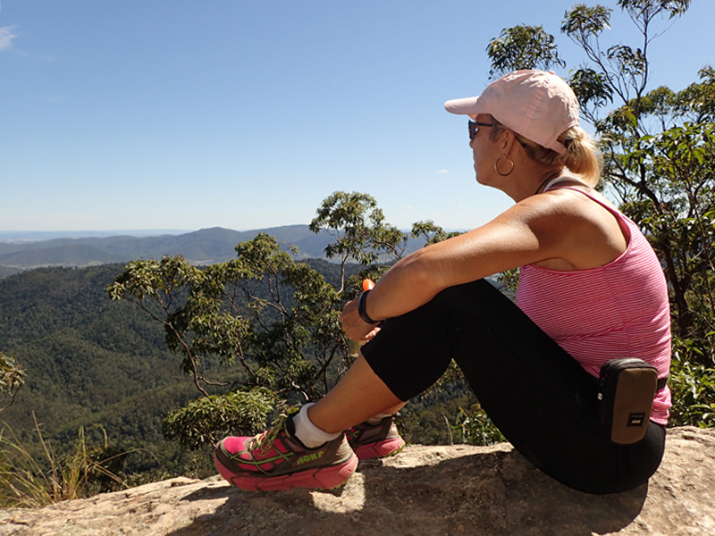
I have done the Somerset Trail a couple of times now and I am drawn back to it for a number of reasons. Top of the list is the spectacular view from the Somerset Lookout. Along the western escarpment are a number of large rock ledges where it is easy to set up the stove and boil the billy for a cuppa. The view across to Somerset Dam and further out to Wivenhoe is spectacular from these vantage points, and the chime of the Bellbirds wafting up from the forest below is one of my favourite sounds of the bush.
The walk starts from The Gantry and follows a 13 km circuit through rainforest, pine plantation, dry open forest and scribbly gum forest. This is a relatively easy walk, rated Class 4 though, it is reasonably exposed once out of the rainforest so in the middle of a summer day it will be warm going. It takes me about 4 hours, but I am one to experience my surroundings so I am often peering at gum nuts and wildflowers, or burnt out trees tenaciously remaining upright, and it really does depend on how long you want to spend drinking in the spectacular westerly panorama to the peal of the Bellbirds rising from the canopy below.
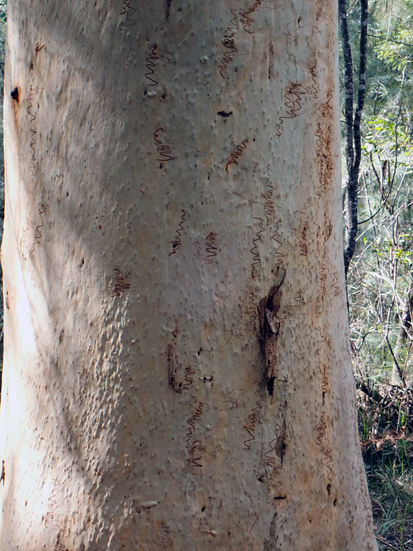
After leaving the rainforest and remnant pine plantation, you will enter Scribbly Gum forest; another of the reasons that I love this walk.
Scribbly Gum are an iconic feature of the forests of south eastern Australia. Not confined to one species of Eucalypt, scribbly gum moth larvae bore meandering tunnels in the trunks of smooth-barked Eucalyptus. The result is a tableau of brown ‘scribble’ graffiti against the white trunk of these magnificent trees.
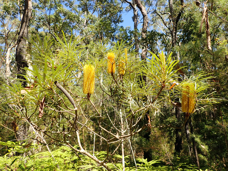
A couple of other reasons for loving this walk are the yellow banksia (Banksia spinulosa var. collina) which flower through the cooler months, and the Xanthorrhoea glauca (Grasstree), which is typified by flowers that are long cylindrical spikes, that can be 3 metres long, growing out of the tuft of spiky foliage.
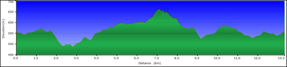
The Somerset Trail starts at about 550 metres above sea level. It is a little bit of up, a little bit of down, but mostly up, to the Somerset Lookout at 650 metres, 7 km in. Being a circuit, the return, logically, is mostly down with the final kilometre backtracking through the dense canopy of the rainforest.
When I was last here in November 2016 there was at least one felled tree across the path but it hasn’t taken long for a detour to be worn through the undergrowth so that is not a great hindrance.
There is no water available on the circuit so you need to carry sufficient. The trail shares this part of the park with four-wheel drive and motorcycle tracks that criss-cross the side of Mount Mee, and there are 12 intersections where you have to cross these tracks. You can hear the vehicles before you see them, but I have encountered only a few on these crossings. You will have to share the lookout with people who have opted to drive up to take in the view, but that is the nature of sharing our great outdoors.
If you don’t want to lunch atop the escarpment you can opt to have a picnic at the Gantry. This is a beautiful grassed area with picnic tables, barbecues, water and toilets. It is overlooked by “The Gantry”, a legacy of the timber industry that was established in the late 19th century. From the 1870s Blackbutt, Flooded Gum, Silky Oak, and Cedar were being felled. The Gantry was built in the 1950s to house the overhead gantry crane, part of Hancock’s sawmill that commenced operations in the 1930s.
I note that the structure is currently closed (as of November 2016), but the picnic area remains a beautiful spot for a cool summer picnic.
After your picnic, the final reason why I love this walk is the getting there. The drive down the western side of Mount Mee to Dayboro is beautiful; winding down the mountain, it is a favourite for motorcycles, and it doesn’t take much to pull over enough to let them past so that everyone can enjoy this beautiful part of the south east.
Stats
Location: D’Aguilar National Park – Mount Mee Section
Access point: The Gantry picnic area, Sellin Road, Mount Mee
Length: 13 km / 4 hours
Grade: Class 4
Links
D’Aguilar National Park website
D’Aguilar National Park locality map
RACQ D’Aguilar Range visitor guide
Guide to the Australian walking track grading system


 are a unique and iconic Australian species")

")


